Openlayers2唯一值渲染
概述
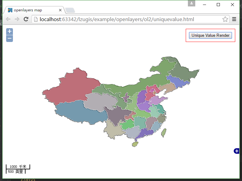
本文讲述Openlayers2中实现唯一值渲染。
效果

源代码
<!DOCTYPE html>
<html>
<head lang="en">
    <meta charset="UTF-8">
    <title>openlayers map</title>
    <link rel="stylesheet" href="../../../plugin/OpenLayers-2.13.1/theme/default/style.css" type="text/css">
    <style>
        html, body, #map{
            padding:0;
            margin:0;
            height:100%;
            width:100%;
            overflow: hidden;
        }
    </style>
    <script src="../../../plugin/OpenLayers-2.13.1/OpenLayers.js"></script>
    <script src="../../../plugin/jquery/jquery-1.8.3.js"></script>
    <script>
        var map;
        var tiled;
        OpenLayers.IMAGE_RELOAD_ATTEMPTS = 5;
        OpenLayers.DOTS_PER_INCH = 25.4 / 0.28;
        $(window).load(function() {
            var format = 'image/png';
            var bounds = new OpenLayers.Bounds(
                    73.45100463562233, 18.16324718764174,
                    134.97679764650596, 53.531943152223576
            );
            var options = {
                controls: [],
                maxExtent: bounds,
                maxResolution: 0.2403351289487642,
                projection: "EPSG:4326",
                units: 'degrees'
            };
            map = new OpenLayers.Map('map', options);
            tiled = new OpenLayers.Layer.WMS(
                    "Geoserver layers - Tiled",
                    "http://localhost:8088/geoserver/lzugis/wms",
                    {
                        "LAYERS": 'province',
                        "STYLES": '',
                        format: format
                    },
                    {
                        buffer: 0,
                        displayOutsideMaxExtent: true,
                        isBaseLayer: true,
                        yx : {'EPSG:4326' : true}
                    }
            );
            map.addLayers([tiled]);
            OpenLayers.INCHES_PER_UNIT["千米"] = OpenLayers.INCHES_PER_UNIT["km"];
            OpenLayers.INCHES_PER_UNIT["米"] = OpenLayers.INCHES_PER_UNIT["m"];
            OpenLayers.INCHES_PER_UNIT["英里"] = OpenLayers.INCHES_PER_UNIT["mi"];
            OpenLayers.INCHES_PER_UNIT["英寸"] = OpenLayers.INCHES_PER_UNIT["ft"];
            //比例尺
            map.addControl(new OpenLayers.Control.ScaleLine({topOutUnits:"千米",topInUnits:"米",bottomOutUnits:"英里",
                bottomInUnits:"英寸"
            }));
            map.addControl(new OpenLayers.Control.Zoom());
            map.addControl(new OpenLayers.Control.Navigation());
            map.addControl(new OpenLayers.Control.OverviewMap());
            map.zoomToExtent(bounds);
            var styleMap = new OpenLayers.StyleMap(null,{
                "select": new OpenLayers.Style({
                    fillColor: "#ffffff",
                    strokeColor: "#00ffff",
                    graphicZIndex: 2,
                    opacity:0
                })
            });
            var lookup = {
                "230000":{fillColor: "#386d2c", strokeColor: "#ffffff",strokeWidth: 1},
                "650000":{fillColor: "#db152e", strokeColor: "#ffffff",strokeWidth: 1},
                "140000":{fillColor: "#7615d8", strokeColor: "#ffffff",strokeWidth: 1},
                "640000":{fillColor: "#7e3c72", strokeColor: "#ffffff",strokeWidth: 1},
                "540000":{fillColor: "#2482b4", strokeColor: "#ffffff",strokeWidth: 1},
                "370000":{fillColor: "#db79f6", strokeColor: "#ffffff",strokeWidth: 1},
                "410000":{fillColor: "#9841fc", strokeColor: "#ffffff",strokeWidth: 1},
                "320000":{fillColor: "#05bc8c", strokeColor: "#ffffff",strokeWidth: 1},
                "340000":{fillColor: "#81fac1", strokeColor: "#ffffff",strokeWidth: 1},
                "420000":{fillColor: "#68e436", strokeColor: "#ffffff",strokeWidth: 1},
                "330000":{fillColor: "#6f7d48", strokeColor: "#ffffff",strokeWidth: 1},
                "360000":{fillColor: "#9f7083", strokeColor: "#ffffff",strokeWidth: 1},
                "430000":{fillColor: "#48c89c", strokeColor: "#ffffff",strokeWidth: 1},
                "530000":{fillColor: "#e0d9a7", strokeColor: "#ffffff",strokeWidth: 1},
                "520000":{fillColor: "#25e635", strokeColor: "#ffffff",strokeWidth: 1},
                "350000":{fillColor: "#78bcde", strokeColor: "#ffffff",strokeWidth: 1},
                "450000":{fillColor: "#b8c7e9", strokeColor: "#ffffff",strokeWidth: 1},
                "440000":{fillColor: "#451cd3", strokeColor: "#ffffff",strokeWidth: 1},
                "460000":{fillColor: "#bad932", strokeColor: "#ffffff",strokeWidth: 1},
                "220000":{fillColor: "#3d57ff", strokeColor: "#ffffff",strokeWidth: 1},
                "210000":{fillColor: "#dca16f", strokeColor: "#ffffff",strokeWidth: 1},
                "120000":{fillColor: "#eb7131", strokeColor: "#ffffff",strokeWidth: 1},
                "630000":{fillColor: "#beb4c0", strokeColor: "#ffffff",strokeWidth: 1},
                "620000":{fillColor: "#449338", strokeColor: "#ffffff",strokeWidth: 1},
                "610000":{fillColor: "#7dd64c", strokeColor: "#ffffff",strokeWidth: 1},
                "150000":{fillColor: "#3e9c10", strokeColor: "#ffffff",strokeWidth: 1},
                "500000":{fillColor: "#cf4d49", strokeColor: "#ffffff",strokeWidth: 1},
                "130000":{fillColor: "#fd1253", strokeColor: "#ffffff",strokeWidth: 1},
                "310000":{fillColor: "#7ea79a", strokeColor: "#ffffff",strokeWidth: 1},
                "110000":{fillColor: "#eb01b6", strokeColor: "#ffffff",strokeWidth: 1},
                "710000":{fillColor: "#97d24c", strokeColor: "#ffffff",strokeWidth: 1},
                "810000":{fillColor: "#46d4e7", strokeColor: "#ffffff",strokeWidth: 1},
                "820000":{fillColor: "#09158f", strokeColor: "#ffffff",strokeWidth: 1},
                "510000":{fillColor: "#583957", strokeColor: "#ffffff",strokeWidth: 1}
            };
            styleMap.addUniqueValueRules("default", "dzm", lookup);
            var vector_layer = new OpenLayers.Layer.Vector("pro",{
                styleMap: styleMap
            });
            map.addLayer(vector_layer);
            $("#geojson").on("click",function(){
                $.get("data/province.geojson",null,function(result){
                    result = eval("("+result+")");
                    var geojson_format = new OpenLayers.Format.GeoJSON();
                    vector_layer.addFeatures(geojson_format.read(result));
                });
            });
        });
    </script>
</head>
<body>
<div id="map">
    <div style="position: absolute;top: 10pt;right: 10pt;z-index: 999;background: #fff;border: 1px solid #f00;padding: 10px;">
        <button id="geojson">Unique Value Render</button>
    </div>
</div>
</body>
</html>
传播GIS知识 | 交流GIS经验 | 分享GIS价值 | 专注GIS发展
技术博客
http://blog.csdn.net/gisshixisheng
在线教程
http://edu.csdn.net/course/detail/799
Github
https://github.com/lzugis/
联系方式
q q:1004740957
e-mail:niujp08@qq.com
公众号:lzugis15
Q Q 群:452117357(webgis)
337469080(Android)

转载自:https://blog.csdn.net/GISShiXiSheng/article/details/51778323


