用openlayer加载arcgis发布的wmts图层
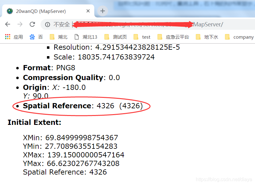
1. 通过wmts 确认发布的wmts是什么格式的。格分为4326,4490,还有可以是4490与4326的混合,归定义的是4490但用的是4320的分辨率。下图是4326格式与其对应的分辨率


下面是4490格式与其对应分辨率


2。对于4490格式,需要在网页里加载proj4js文件: <script type=”text/javascript” src=”../libs/proj4js/2.5.0/proj4.js”></script>
3. 4490 projection定义:
openlayer2:
proj4.defs(“EPSG:4490″,”+proj=longlat +ellps=GRS80 +no_defs”);
var projection = new OpenLayers.Projection(‘EPSG:4490’);
openlayer 3:
proj4.defs(“EPSG:4490”, “+proj=longlat +ellps=GRS80 +no_defs”);
var projection = new ol.proj.get(‘EPSG:4490’);
projection.setExtent([-180,-90,180,90]);
4. 代码实现,下面url中的{Style}与{TileMatrixSet}要被替换
openlayer2中用OpenLayers.Layer.XYZ,建图层:
url = “http://wmtsnetwf.com/services/QQ/WMTS/tile/1.0.0/CQMap_IMG/{Style}/{TileMatrixSet}/${z}/${y}/${z}”;
var wmtsXYZ2 = new OpenLayers.Layer.XYZ(
“wmts”,
url,
{
sphericalMercator: false,
isBaseLayer: false,
serverResolutions:titleresolutions4490
});
openlayer3中或ol.source.XYZ与ol.layer.Tile,建图层:
url = “http://wmtsnetwf.com/services/QQ/WMTS/tile/1.0.0/CQMap_IMG/{Style}/{TileMatrixSet}/{z}/{y}/{z}”;
var wmtsSouceXYZ = new ol.source.XYZ({
attributions: “wmts”,
maxZoom: 18,
projection: projection,
tileSize: [256, 256],
//tileGrid: new ol.tilegrid.TileGrid({ //4490+4326
// tileSize:256,
// origin: vOrigin,
// resolutions: resolutions,
// matrixIds: matrixIds
//}),
tileUrlFunction: function (tileCoord) {
var z = tileCoord[0]-1, x =tileCoord[1], y = -tileCoord[2]-1; //4490
// var z = tileCoord[0],x = tileCoord[1], y = -tileCoord[2]-1; //4490+4326
return url.replace(‘{z}’, (z).toString())
.replace(‘{x}’, (x).toString())
.replace(‘{y}’, (y).toString());
}
})
var wmtsLayer = new ol.layer.Tile({
opacity: 0.7,
source:wmtsSouceXYZ
});
转载自:https://blog.csdn.net/diaya/article/details/85342112


