扩展DynamicMapServiceLayer和TiledMapServiceLayer,实现访问wms数据和自定义切图数据
一下代码是silverlight写的,flex思路都一样,只是一些方式有些不一样,flex里都是重载属性,flex的例子里都有,自己下载下来看看
1:扩展DynamicMapServiceLayer
如果后台数据通过geoserver发布wms数据,我们可以通过继承DynamicMapServiceLayer的接口实现访问geoserver发布的wms服务,可以参考http://bbs.esrichina-bj.cn/ESRI/thread-45582-1-1.html
代码如下
调用代码
/// <summary>
/// gepserver的wms数据加载
/// </summary>
private void LoadWmsMapServiceLayer()
{
int KWID = 4326;
Envelope extent= new ESRI.ArcGIS.Client.Geometry.Envelope(-124.731, 24.956, -66.97, 49.372);
extent.SpatialReference = new SpatialReference(KWID);
string Url = “http://localhost:8080/geoserver/wms”;
string [] layers=new string []{‘topp:states’};
WMSMapServiceLayer wms = new WMSMapServiceLayer(extent, KWID, Url,layers);
this.mymap.Layers.Add(wms);
}
自定义wms类
public class WMSMapServiceLayer:DynamicMapServiceLayer 继承接口,实现GetUrl方法
{
List<string> _layers = new List<string>();
public WMSMapServiceLayer(Envelope extent, int KWID, string url,string [] layers)
{
this.FullExtent = extent; //地图范围
this.SpatialReference = new ESRI.ArcGIS.Client.Geometry.SpatialReference(KWID); //空间参考
this.Url = url; wms地址
this.Version = “1.1.1”; //wms版本
this.Layers = layers; //请求的图层
// _layers.Add(“topp:states”);
}
public string Url { get; set; }
public string Version { get; set; }
public string[] Layers
{
get { return _layers.ToArray(); }
set { _layers = new List<string>(value); OnLayerChanged(); }
}
public override void Initialize()
{
this.FullExtent = Extent; 设置范围 //不设置就无法实现
this.SpatialReference = new SpatialReference(KWID);
base.Initialize();
}
//重写获取数据接口的方法
public override void GetUrl(ESRI.ArcGIS.Client.Geometry.Envelope extent, int width, int height, DynamicMapServiceLayer.OnUrlComplete onComplete)
{
int extentWKID = extent.SpatialReference.WKID;
StringBuilder mapURL = new StringBuilder();
mapURL.Append( Url);
mapURL.Append(“?service=WMS”);
mapURL.Append(“&request=GetMap”);
mapURL.AppendFormat(“&width={0}”, width);
mapURL.AppendFormat(“&height={0}”, height);
mapURL.AppendFormat(“&format={0}”, “image/png”);
mapURL.AppendFormat(“&layers={0}”, String.Join(“,”, Layers));
mapURL.Append(“&styles=”);
mapURL.AppendFormat(“&bgcolor={0}”, “0xFFFFFF”);
mapURL.AppendFormat(“&transparent={0}”, “true”);
mapURL.AppendFormat(“&version={0}”, Version);
switch (Version)
{
case (“1.1.1”): mapURL.AppendFormat(“&SRS=EPSG:{0}”, extentWKID);
mapURL.AppendFormat(CultureInfo.InvariantCulture, “&bbox={0},{1},{2},{3}”,
extent.XMin, extent.YMin, extent.XMax, extent.YMax); break;
}
//把哪些字符串拼接起来,跟openlayer一样的
onComplete(mapURL.ToString(), width, height, new ESRI.ArcGIS.Client.Geometry.Envelope()
{
XMin = extent.XMin, YMin = extent.YMin, XMax = extent.XMax, YMax = extent.YMax
});
}
}
2:扩展TiledMapServiceLayer ,跟扩展DynamicMapServiceLayer差不多,关键就是设置一些访问必须的属性
public class CustomTileCache:TiledMapServiceLayer
{
public CustomTileCache(Envelope extent, int KWID, string url, int width, int height, int level, double resolution)
{
this.Extent = extent;
this.KWID = KWID;
this.Url = url;
this.Width = width;
this.Height = height;
this.Resolution = resolution;
this.Level = level;
}
public Envelope Extent { get; set;}
public int KWID { get; set; }
public string Url { get; set; }
public int Width { get; set; }
public int Height { get; set; }
public int Level { get; set; }
public double Resolution { get; set; }
public override void Initialize()
{
this.FullExtent = Extent; //范围
this.SpatialReference = new SpatialReference(this.KWID); 空间参考
this.TileInfo = new TileInfo() 瓦片的具体信息
{
Height = Height, 每张瓦片的高度,一般为256或者512
Width = Width,
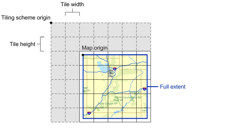
Origin = new MapPoint(this.FullExtent.XMin, this.FullExtent.YMax) //下图有解释
{
SpatialReference = new SpatialReference(KWID)
},
Lods = new Lod[Level]
//Lod [] lods=new Lod[];
};
for (int i = 0; i < this.TileInfo.Lods.Length; i++)
{
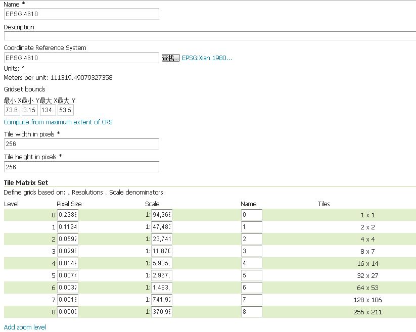
TileInfo.Lods[i] = new Lod() 设置分辨率。 切图方式不一样,这里就不一样,我是比例尺是1/2方式去切的
{
Resolution = Resolution
};
Resolution = Resolution / 2;
}
base.Initialize();
}
public override string GetTileUrl(int level, int row, int col)
{
//自己数据的切片规则
string url = Url + “zoom_” + (level + 1).ToString() + “/x” + col.ToString() + “/” + (level + 1).ToString() + “_” + col.ToString() + “_” + row.ToString() + “.png”;
return url;
}
}
可以查一些瓦片切图的资料

转载自:https://blog.csdn.net/xinruogis/article/details/5567103


